 Seminar by Dr. Scott Hensley
NASA Jet Propulsion
Laboratory
"Mapping Beneath the
Vegetation:
The GeoSAR Mapping Instrument"
3:30pm ,
Wednesday,
June 8, 2005
NASA
Goddard Visitor Center
Sponsored by the Washington/Northern
Virginia Chapter of the
IEEE
Geoscience and Remote Sensing Society
Seminar Abstract: GeoSAR
is a program to develop a dual frequency airborne radar interferometric
mapping instrument designed to meet the mapping needs of a variety of users in
government and private industry. Program participants are the Jet Propulsion
Laboratory (JPL), Earthdata International, Inc., and
the California Department of Conservation with funding provided initially by
DARPA and currently by the National Imagery and Mapping Agency.
Begun to address
the critical mapping needs of the California Department of Conservation to map
seismic and landslide hazards throughout the state, GeoSAR
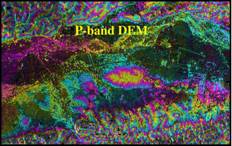
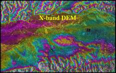
is currently undergoing tests of the X-band and P-band radars designed to measure
the terrain elevation at the top and bottom of the vegetation canopy. Maps
created with the GeoSAR data will be used to assess
potential geologic and seismic hazards (such as landslides), classify land
cover, map farmlands and urbanization, and manage forest harvests.
This talk will present an overview of the system and show
some examples of X- and P-band data and maps generated using the GeoSAR systems and comparison with other sensor data such
as LIDAR and photogrammetric data.
Dr. Scott Hensley received his B.S. degrees
in mathematics and physics from the
In 1992, Dr.
Hensley joined the staff of the Jet Propulsion Laboratory where he studies
advanced radar techniques for geophysical applications. His research has
involved using both stereo and interferometric data
acquired by the Magellan spacecraft at Venus. Dr. Hensley has worked with
ERS-1, JERS-1 and SIR-C data for differential interferometry
studies of earthquakes and volcanoes. Current research also includes studying
the amount of penetration into the vegetation canopy using simultaneous L and C
band TOPSAR measurements and repeat pass airborne interferometry
data collected at lower frequencies.
Dr. Hensley was
the GeoSAR Chief Scientist and lead
the GeoSAR Processing and Algorithm Development Team
for an airborne interferometric radar mapping
instrument using X- and P-bands for mapping true ground surface heights beneath
the vegetation canopy. He was the technical lead of the SRTM Interferometric Processor Development Team that was a
shuttle based interferometric radar used to map the
Earth’s topography between ±60° latitude.
Dr. Hensley is
currently a member of the Cassini radar science team
(mapping the surface of Titan, a moon of Saturn) and the Chief Scientist for
the UAVSAR an airborne radar being designed and built to map deformation from
both natural (earthquakes, volcanoes, and glaciers) and anthropogenic sources
(water and oil pumping).