
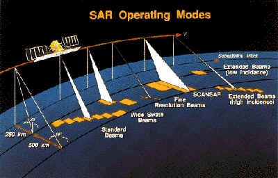
RADARSAT is a sophisticated Earth observation (EO) satellite developed by Canada to monitor environmental change and the planet's natural resources and to support resource sustainability. Launched in November1995, RADARSAT provides Canada and the world with an operational radar satellite system capable of timely delivery of large amounts of data. RADARSAT also provides useful information to both commercial and scientific users in the fields of agriculture, cartography, hydrology, forestry, oceanography, ice studies and coastal monitoring.
With the launch of RADARSAT-1 in November 1995, Canada and the world have access to the first fully operational civilian radar satellite system capable of large scale production and timely delivery of data. The data from the satellite meets the needs of commercial, government and scientific programs and provides a new and reliable source of high quality radar data.
The RADARSAT program, led by the Canadian Space Agency (CSA), builds on the history of achievement in remote sensing by the Canada Centre for Remote Sensing (CCRS), Natural Resources Canada. With its creation in 1989, CSA took over the implementation and operation of the RADARSAT project as a key component of the Canadian space program. CCRS continues to participate in the RADARSAT program by operating Canada's two RADARSAT ground receiving stations located in Prince Albert, Saskatchewan and Gatineau, Québec, and conducting applications research.